From North to South
Amy's ramblings. Once upon a time these ramblings pertained to my 5 months in Guatemala and Honduras. Then they followed the ebb and flow of my final semester in Alaska. From there things really went south ... to Argentina, Bolivia and Chile. After 8 months in the Andes, I fell back under Alaska's spell … working at a newspaper and wandering mountains. Now I'm somewhat south again ... in Jackson Hole, WY, teaching ski school on the clock and making fresh tracks off the clock.
About Me
- Name: Amy
- Location: Alaska, United States
I've come to realize that if you have faith in the world, the world will show you amazing and beautiful people, places and things
Monday, October 25, 2010
Sunday, October 24, 2010
Reverberations
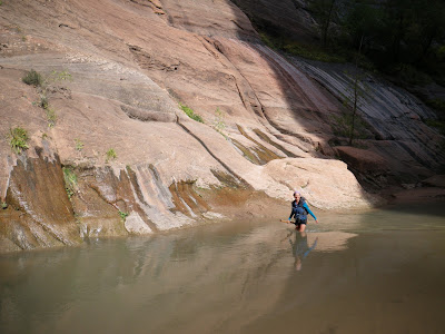
The day we arrived, we hiked, aka waded, through The Narrows ... a river that winds for miles on end through a narrow canyon. The river is a marked route, and some, like us, make the journey in old tennis shoes and shorts, while others come more prepared - with wet suits and even dry suits. We arrived on a baking hot sunny day, making our methodology for The Narrows fairly manageable, although I was a bit chilled by the time we exited back on to dry ground.
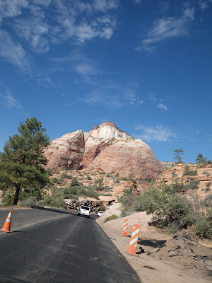
After a night in the luxurious and cozy lodge in Zion National Park, we woke early to hike up to the Emerald Pools. We had the place to ourselves and reveled in its beauty and powerful energy. After a quick breakfast, we set back out on the road, headed first to Salt Lake City, to drop mom off at the airport, then back to Jackson, to be back at work Monday.
All in all, it was an epic, rejuvenating, spectacular mini-vaca to canyon country.
Labels: Amy, canyon country, Mom, photos, Utah, Zion National Park
North to south .... to north
Instead Karen Williams and I ran from the north rim to the south rim and back to the north rim of the Grand Canyon in a spectacular - and sometimes grueling - 17 hours. The round-trip distance closed in on 50 miles and the elevation gain and loss was too intimidating to even calculate.
On the north rim 16 of us Alaskans, former Alaskans and friends of Alaskans congregated for an epically fun couple of days. Everyone went their own speed: there were rim to rimmers, rimer to river to rimers, and the rim to rim to rimmmers.(Of note, my mom and Karen's husband Kent hiked nearly 30 miles, going from the north rim to the river and back!)
We ran/ hiked on Thursday (10/14) and then all hung out and celebrated together on Friday. I spent the better part of Friday sitting on a veranda perched on the north rim, drinking coffee, reading and generally refusing to move. (I let out more than a few grumbles about the idea of walking 0.6 miles to a lookout for sunset, but in the end was lulled into the idea ... and it turned out to be worth the effort).
The highlights were many: reconnecting with friends and meeting new ones; descending in the dark with headlamps; listening to all the off-the-wall comments people made about our endeavor, especially when going back down the south rim and passing the same people we passed on the way up; gorging on a milkshake, hamburger, fries and coffee on the south rim; jumping into the water with all of our clothes on to cool down; crossing the bridge over the river in the bottom of the canyon; sitting with our backs against a sheer cliff admiring the stars overhead and the moonlit canyon below us; and mildly hallucinating, with the sound of water washing over me, reverberating off the canyon walls and then engulfing in me in a peaceful calm.
Our mantra for the day, and for ultrarunning in general, was in the forefront of our thoughts: there's no place I'd rather be than right here, right now, right at this point on the trail.
Labels: Grand Canyon, Karen, Mom, photos, Rim to rim to rim, running, Trail running, Travel, ultrarunning
Saturday, October 09, 2010
Let the wind take my troubles away
Out my window poured the song “Windfall” by Son Volt.
“Both feet on the floor, two hands on the wheel, may the wind take your troubles away.”
With each passing mile my “troubles” i.e. the cares and stresses of the week dissolved, replaced by a penetrating inner peace.
Just me and my dog. Just me and my dog headed to the mountains. Just me and my dog headed to the mountains on a dazzling autumn day.
I relished the feeling of having a whole day to follow my creative whims.
The night before I poured over the map and came up with a circular traverse full of possibility. The topographic lines promised passable terrain and the location – a ridge directly to the west of the Grand Teton – hinted at stunning views.
I planned to go up Table Mountain – a hike that’s been on my to do list for some time – but, at the top, rather than retrace my steps, with the Sunday afternoon swarms, I hoped to traverse across to Hurricane Pass and descend via the Alaska Basin Trail.
I’d never been on any of these trails – or lack of trails as was the case for one section of my planned route – and with the extra edge of doing it by myself, the anticipation made me feel alive and free.
I pulled up to the parking lot at the end of Teton Canyon at 11 a.m. It was later in the day than I would have liked, but since I planned to half-hike half-run the route, I still had plenty of time to complete the guesstimated 17 miles before sunset.
There’s two ways to get up Table Mountain: the short and steep route or longer and semi-steep route. I was aiming for the short and steep route, but since only the trailhead for the longer and semi-steep route is marked, that’s where I found myself.
No matter. It followed a river, giving Zippy, my dog plenty of opportunity to hydrate.
(Scroll down to keep reading the day's narrative)
We jogged through aspens groves, bursting with circus colors, winding our way toward a plateau at the end of a basin.
For a long time – due to our late start – Zippy and I had the trail entirely to ourselves; but as we approached the summit of Table, the five-mile single track took on overtones of a highway.
The final section arcs across a sweeping ridge, and people dotted it as far as the eye could see.
Crawling carefully over loose gravel, Zippy and I crested the summit of Table Mountain, elevation 11,106 feet.
If you’ve never sat on Table Mountain on a clear day, you should.
It feels like you can reach your pointer finger out and caress the Grand’s rough, jagged, rock-strewn sides. You feel like a queen on a throne and an ant on a sandcastle – at the exact same time.
We sat up there, under the warmth of early October’s afternoon sun, eating lunch for nearly an hour – I shared some of my almond butter and jelly sandwich with my brown eyed, floppy eared pup, who chowed appreciatively.
Stomachs and spirits full, it was time for the real adventure to begin.
From Table Mountain I had a clear view to Hurricane Pass, and picked out a route and way markers: a snowfield shaped like a V, a grassy knoll and a scree field full of volcanic rocks.
With one last glance at the Grand, I was off. I tiptoed up to the edge of a bluff. Using a steep gully filled with dead grass and a scattering of loose boulders, I picked my way down.
Arriving at the bottom, I knew there was no turning back.
I then set out cross-country, hugging the shade of a few small trees as long as I could, before being funneled into a field of black, abrasive boulders.
As the sun beat down and the rocks baked from below, I began to wish I’d worn sunscreen. Instead I periodically gave Zippy a few gingerly sips of water from my Camelbak.
I then had to make my way up through a rock band that wrapped around most of the mountain side, like a ribbon on a gift.
I found a ravine that looked passable and started scrambling up it, faithful pup in toe. About half way up, loose rock began to drain out from underneath my feet.
Keeping my cool, but admittedly a bit unnerved, I was relieved when both Zippy and I reached semi-horizontal, grass-stabilized ground. (Note: if you attempt this route, there’s a much simpler way to get up, as I later discovered, directly below Hurricane Pass).
A short while later, traversing south, I made my way to Hurricane Pass. My total off-trail time was between one to two hours – I wasn’t keeping close track. The distance covered was a bit more than a mile.
In its own way, Hurricane Pass is every bit as spectacular as Table Mountain. An aqua green glacial lake sits like a gum drop directly below the pass, while the Grand towers above.
As I laced up my shoes, I felt a quiver of excitement. Before me, 10 gentle downhill miles twisted next to North Fork Darby Creek.
I easily found a running rhythm, a rhythm that got interrupted occasionally by a rock formation or waterfall so striking that I had to stop and gawk.
Zippy trotted behind me, his rhythm matching mine … through fields of crackling yellow leaves, past a merry marmot and into a refreshing alpine lake. (I didn’t actually go into the lake despite Zippy’s cajoling and assurances that nothing would feel better).
The sun hovered on the horizon, casting long shadows and soft magical light.
For 9.5 miles I saw no living creature, save that merry marmot.
It was just mom and dog in the mountains on a dazzling autumn day.
By the time we closed in on the last half mile, when we had a few sightings of other human beings, the wind had taken my troubles away, and filled my lungs. I was running faster than I would in a flat 5K.
I took that pace right to the parking lot and into a nearby a river – Zippy’s cajoling at work.
Labels: Amy, Hike, photos, ramblings, running, Table Mountain, Tetons, Zippy


